
Business Details
30 Years
experience
Professional Land Surveyors in Kent
Established in 1996, Sitech Surveying Services has built a reputation for delivering precise and reliable land surveying solutions across the UK and internationally. Our expertise spans topographic surveys, measured building surveys, and underground services mapping, supported by advanced technologies like 3D laser scanning and GPS. With two strategically located offices in Maidstone and Cirencester, we serve diverse sectors including construction, design, and infrastructure development. Our team combines over 50 years of collective experience, ensuring tailored services that meet exact client requirements while adhering to strict quality assurance protocols. We utilise the latest AutoCAD software and maintain comprehensive project records to guarantee accuracy and compliance.Our commitment to innovation, competitive pricing, and timely delivery has earned us a proven track record with prestigious clients. We prioritise a personal, client-focused approach, offering both digital and hard-copy deliverables up to A0 size. Health and safety standards are rigorously upheld, particularly during confined space surveys, and we align our utility detection practices with TSA Utility Guidance Note Standards. Our directors, Mike Timbrell and Martin Hegley, bring decades of industry experience from their tenure at Central Survey Branch, ensuring technical excellence and industry leadership. As a fully indemnified provider, we aim to exceed expectations through precision, professionalism, and a dedication to evolving client needs.
Services
Topographic Surveys
Measured Building Surveys
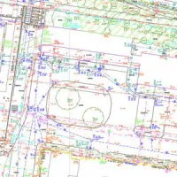
Underground Services Mapping
3D Laser Scanning
Setting Out Surveys
Details
- Year established: 1996
Highlights and features
- We combine over 50 years of combined surveying experience.
- We utilise advanced GPS, 3D laser scanning, and GPR technology.
- Our services are tailored to meet specific project requirements.
- We adhere to TSA Utility Guidance Note Standards for safety and accuracy.
- We maintain full project records for quality assurance compliance.
Services
Topographic Surveys
Topographic surveys capture detailed terrain data using reflectorless and GPS technologies. Ideal for construction planning, environmental assessments, and land management. Our surveys provide accurate elevation models and feature documentation to support engineering and architectural projects.
Measured Building Surveys
Precise building surveys for commercial, residential, and industrial structures. Deliverables include floor plans, elevations, and 3D models. Essential for renovations, space planning, and asset management across all sectors.
Underground Services Mapping
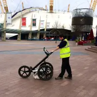
Locate and map underground utilities using electromagnetic detection and GPR. Identifies cables, pipes, and voids to ensure safe excavation. Complies with TSA standards for depth accuracy and service identification.
3D Laser Scanning
High-resolution 3D scans create detailed digital twins of structures and sites. Supports BIM integration, heritage preservation, and structural analysis with millimetre precision.
Setting Out Surveys
Accurate positioning of buildings and infrastructure during construction. Ensures alignment with design specifications using GPS and total station technology for error-free project execution.
People
Mike Timbrell
Director
With over 30 years in surveying, Mike founded Sitech in 1996 after working at Central Survey Branch. He specialises in project management and client relations, ensuring technical excellence and timely delivery.
Martin Hegley
Director
Martin brings extensive field experience from Central Survey Branch, where he pioneered AutoCAD adoption. He focuses on technical operations and quality assurance, maintaining industry-leading standards since joining Sitech in 1996.
Questions
What areas do you cover for surveying services?
We operate throughout the UK, Channel Islands, and overseas. Our offices in Maidstone and Cirencester enable efficient coverage of Kent, Surrey, Sussex, London, Bristol, and Gloucestershire.
What technologies do you use for surveys?
We employ GPS, 3D laser scanning, electromagnetic detection, and ground-penetrating radar (GPR) to ensure accuracy and efficiency across all survey types.
Can you handle urgent surveying projects?
Yes, we prioritise timely delivery and offer rapid response for urgent requirements. Contact us directly for immediate quotations and scheduling.
Do you provide utility mapping for construction sites?
Yes, we specialise in detecting and mapping underground utilities to TSA standards, ensuring safe and compliant excavation planning.
What file formats do you deliver survey data in?
Data is provided digitally via AutoCAD (DWG) or PDF, with options for hard-copy prints up to A0 size in monochrome or colour.
Are your surveyors qualified for confined space work?
Our team is fully trained in confined space safety procedures and adheres to strict health and safety protocols during all surveys.