Business Details
49 Years
experience
Expert Surveying Services in Bures, Suffolk
Established in 1977, we are a multi-disciplinary survey practice operating across the UK. Our team of qualified professionals utilises cutting-edge technology to deliver precise spatial data for land, building, and hydrographic projects. With RICS accreditation and ISO 9001 certification, we prioritise accuracy and client-specific solutions. Our expertise spans topographic mapping, structural monitoring, and underground services detection, serving diverse sectors including construction and utilities.We maintain a 'right-first-time' philosophy, minimising project risks through meticulous data capture and tailored deliverables. Over four decades of experience enable us to tackle complex challenges, from confined space surveys to 3D laser scanning. Our commitment to quality is reflected in repeat client relationships and industry recognition through memberships in The Survey Association and Achilles Utilities database.
Services
Topographic Surveys
Building Surveys
Hydrographic Surveys
Laser Scanning
Structural Monitoring
Utilities Mapping
Specialist Surveys
Details
- Year established: 1977
Highlights and features
- We have 45+ years of surveying experience since 1977
- Our ISO 9001 certification guarantees quality processes
- We utilise the latest laser scanning technology
- Our RICS-registered team ensures professional standards
- We provide tailored solutions for complex survey challenges
Associations and certifications
- Royal Institution of Chartered Surveyors (RICS)
- ISO 9001
- The Survey Association
- Achilles Utilities
Services
Topographic Surveys
We conduct detailed topographic surveys for development sites, including commercial properties, public infrastructure, and environmental projects. Our surveys capture precise elevation data and surface features to support construction planning and land management. Using GPS and total station technology, we deliver accurate digital terrain models and contour maps.
Laser Scanning
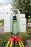
Our high-definition laser scanning creates detailed 3D models of structures and environments. This technology captures millions of data points to produce accurate as-built documentation for architectural, engineering, and heritage projects. We convert point cloud data into BIM-ready models and technical drawings for construction and renovation purposes.
Hydrographic Surveys
We perform specialist hydrographic surveys for coastal, riverine, and port environments. Using multibeam echo sounders and MCA Cat 4 vessels, we map underwater topography for dredging projects, flood risk assessment, and marine infrastructure. Our services include bathymetric mapping and sediment volume calculations for reservoirs and waterways.
Structural Monitoring
We implement structural health monitoring systems for buildings, bridges, and industrial assets. Using precision instruments, we track movements and deformations over time to assess structural integrity. Our monitoring solutions help identify subsidence issues, vibration patterns, and stress factors affecting critical infrastructure.
Utilities Mapping
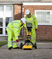
Our underground services location surveys identify buried utilities using electromagnetic detection and ground penetrating radar. We map electrical cables, gas pipes, and drainage systems to prevent utility strikes during construction. The surveys produce detailed CAD drawings showing service routes and depths for safe excavation planning.
Questions
What surveying services do you offer?
We provide topographic, building, hydrographic, and underground services surveys, plus laser scanning and structural monitoring for commercial and infrastructure projects.
Are you accredited by professional institutions?
Yes, we are RICS-registered, ISO 9001 certified, and members of The Survey Association and Achilles Utilities vendor database.
How do you handle complex survey projects?
We combine 45+ years of experience with modern technology like 3D laser scanning to tackle challenging environments including confined spaces and hazardous areas.
What geographic areas do you cover?
We operate nationwide across the UK from our base in Bures, Suffolk, serving clients in construction, utilities, and environmental sectors.
Can you assist with heritage building surveys?
Yes, we specialise in detailed measured surveys of historic and listed buildings using non-invasive techniques to preserve architectural integrity.
What deliverables do you provide?
We supply CAD drawings, point cloud data, 3D models, and GIS-compatible files in both digital and printed formats as required by clients.