
Business Details
50+ Years
experience
Leading Geospatial Surveying Services in the UK
Plowman Craven has been a leader in geospatial surveying for over six decades, delivering precise measurement and consultancy services to property, rail, infrastructure, and logistics sectors. Our expertise combines cutting-edge technology with a commitment to quality, ensuring clients receive accurate data to inform critical decisions. With a global presence spanning the UK, North America, Australia, and India, we serve developers, architects, engineers, and government bodies. Our 170-strong team utilises drones, AI, and BIM software to provide innovative solutions tailored to project lifecycles. Founded in 1964, we maintain a reputation for integrity, technical excellence, and client-focused service.Our investment in R&D and staff development ensures we remain at the forefront of industry advancements. We prioritise sustainability through a Net Zero 2050 target and community engagement initiatives. Our clients benefit from 60 years of experience, a diverse workforce, and partnerships with leading technology providers. We deliver value through enhanced data visualisation tools like Condition Capture, integrating 360 imagery with site plans. Our global expansion, supported by private equity funding, reinforces our ambition to lead the surveying industry worldwide.


Services
Measured Building Surveys
BIM Consultancy
Topographical Surveys
Underground Utilities Mapping
Structural Monitoring
Drone Surveys
Environmental Planning
Rail Surveys
Construction Verification
Digital Twin Development
Details
- Year established: 1964
Highlights and features
- We have over 60 years of experience in geospatial surveying.
- Our team utilises cutting-edge technology including drones and AI.
- We serve a diverse client base across property, rail, and infrastructure sectors.
- We maintain ISO-certified quality standards and Net Zero commitments.
- Our global presence ensures local expertise in multiple international markets.
Services
Measured Building Surveys
Our measured building surveys provide precise architectural and structural data using laser scanning technology. This service supports property development, refurbishment, and heritage conservation projects by creating detailed floor plans, elevations, and 3D models. Clients benefit from accurate dimensional analysis for design validation and construction planning.
BIM Consultancy
Our BIM consultancy services help clients implement Building Information Modelling across project lifecycles. We create intelligent 3D models that integrate spatial data, material specifications, and asset information. This enables improved collaboration, cost estimation, and maintenance planning for complex infrastructure and building projects.
Topographical Surveys
We conduct topographical surveys to map terrain features, elevations, and existing structures using GPS and drone technology. This data supports site analysis, drainage planning, and infrastructure design. Clients receive detailed contour maps and digital terrain models for engineering and environmental assessments.
Underground Utilities Mapping
Our underground utility mapping service locates and records buried services using ground-penetrating radar and electromagnetic detection. This prevents costly strikes during excavation and supports utility network management. Clients receive GIS-compatible data showing precise locations of water, gas, and electrical infrastructure.
Drone Surveys
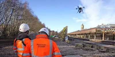
We deploy drones for aerial surveys and infrastructure inspections, capturing high-resolution imagery and 3D photogrammetry. This enables safe, rapid data collection for large sites, building facades, and rail corridors. Clients benefit from reduced site disruption and enhanced health-and-safety compliance.
Questions
What services does Plowman Craven offer?
We provide measured building surveys, BIM consultancy, topographical mapping, underground utilities detection, drone inspections, and structural monitoring for property, rail, and infrastructure sectors.
Which industries do you specialise in?
Our primary focus areas include property development, rail infrastructure, logistics facilities, and urban regeneration projects across the UK and international markets.
How do you ensure data accuracy?
We use laser scanning, photogrammetry, and AI-enhanced technologies combined with ISO-standard processes to guarantee survey data precision within millimetre tolerances.
Can you handle large-scale infrastructure projects?
Yes, our experience includes major rail networks, urban regeneration schemes, and multi-site logistics developments using coordinated national and international teams.
What technology do you use?
We employ drones, terrestrial laser scanners, gyroscopic mapping systems, and BIM software to create digital twins and 3D models for project visualisation.
How do you support sustainability goals?
Our digital surveying methods reduce site visits, lower carbon emissions, and support clients' Net Zero strategies through accurate data-driven decision-making.
Videos