
Measured Precision
SJ Geomatics Ltd delivers comprehensive land, engineering and specialist surveying services across the UK, supporting residential, commercial and infrastructure developments. We work closely with our clients from initial feasibility and design stages through to construction and final handover, providing precise, construction-ready information tailored to project requirements. Our approach is defined by accuracy, clarity and consistency, underpinned by responsive communication and reliable delivery timescales that allow projects to progress with confidence.
Our service offering encompasses topographical and measured building surveys, including detailed plans, elevations and sections, alongside utility and GPR surveys, CCTV inspections, and setting out and engineering support such as control, verification checks and as-built surveys. We also provide advanced data capture and modelling solutions, including 3D laser scanning with BIM-compatible outputs, as well as drone surveys and aerial mapping for efficient data collection on large or restricted sites. Our specialist expertise extends to rebar detection, bathymetric sonar and thermographic surveys. In addition, we prepare Land Registry-compliant plans and offer AutoCAD drafting services, covering survey drawings, amendments and comprehensive as-built documentation. As a fully accredited and professionally aligned supplier, we maintain recognised certifications and ISO standards, ensuring dependable results for both single commissions and ongoing multi-site support.
- Nationwide
- Year established: 2012
- Employees: 6
- Licensed
- Insured
- Nationwide land and building surveys delivered with precision
- Professional friendly service with proven surveying expertise nationwide
- State-of-the-art equipment ensuring accurate high-quality survey results consistently
- Comprehensive surveying solutions from planning through construction stages
- Experienced surveyors trusted by public and private sector clients
- Cost-effective time-sensitive services tailored to project requirements nationwide
- Chartered ICES
- ISO9001
- ISO14001
- ISO27001
- ISO45001
- ISO22301
- Constructionline Gold
- Achilles
- Accredit
- Joscar
- SMAS - SSIP
- Arpas UK - The Drone Association
- Suffolk Chamber of Commerce
- Federation of Small Businesses
- Checks, Debit cards, Credit cards, Bank transfers
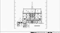 Our Measured Building Surveys form a vital element of the planning process for architectural, development and construction projects. We utilise advanced surveying software and equipment to deliver accurate floor plans, elevations and sections for properties of any size or age. Each survey is tailored to the individual requirements of private clients and commercial developers alike, ensuring reliable, high-quality outputs.
 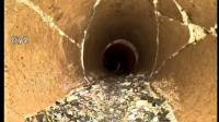 We undertake CCTV Surveys to deliver accurate visual assessments of drainage networks and pipe systems, helping to verify connections and identify defects at an early stage. Using specialist camera technology, we detect issues such as cracking, joint displacement, root ingress, silt build-up, blockages and structural failure. These surveys are suitable for property transactions, asset reviews, drainage validation and construction-related inspections. Clients receive recorded footage, inspection schedules and a clear condition summary.