Elevate your projects with precision
Since its establishment in 2011 by Michael Brett, CADMAP Limited has evolved into a respected UK surveying and geomatics firm. Michael, drawing upon a surveying career that commenced in 1999, brought together technical expertise in land surveying, geomatics, CAD management and digital marketing to form the foundation of the company. We continue to uphold his vision in all aspects of our operations.
We deliver a comprehensive range of surveying services, including topographical land surveys, measured building surveys, PAS 128 compliant utility mapping, CCTV drainage surveys, laser scanning and BIM modelling. Our solutions provide accurate and reliable outputs for architects, engineers, developers, infrastructure companies and government organisations. Operating across London, the South East and the wider United Kingdom, we ensure consistent quality and precision across all commissioned projects.
- The whole UK - London, Surrey, Sussex, South East
- Year established: 2011
- Employees: 25
- Licensed
- Insured
- Topographical Surveys
- GPR Surveys
- Measured Building Surveys
- BIM Scanning
- Rebar Scanning
- Concrete Scanning for depth and Rebar
- 3D Scanning
- Revit Models
- Drainage Surveys
- CCTV Drainage Surveys and Jetting
- Full Member the TSA - The Survey Association
- CICES
- Bank transfers
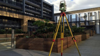 Our topographical surveying service delivers accurate land and site information essential for successful project planning and future development. We map ground features and levels precisely, allowing clients to progress with confidence during the design stage. We work with a wide range of clients, including planners, architects, and developers, using advanced Leica surveying technology. All surveyors are fully trained and hold the relevant site access and clearance certifications.
 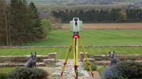 We offer measured building survey services providing precise spatial data for design and planning projects. Our surveyors create detailed floor plans, elevations, sections, and CAD drawings based on accurate site measurements. We collaborate with professionals involved in property development across multiple regions. Digital deliverables are available in DWG, DXF, and PDF formats for ease of use. Our work ensures consistency and compliance with industry standards.
 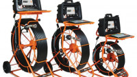 We utilise the latest CCTV camera systems to deliver comprehensive drainage surveys for clients. Our MiniCam Solo Pro 100 metre drain camera is deployed alongside Wincan V8 software for detailed reporting. The equipment enables accurate inspection of underground pipe conditions and system layout. This approach ensures reliable assessment of drainage infrastructure and its operational state.
 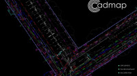 Cadmap Limited carries PAS128 GPRS surveys serving clients from homeowners through to blue chip. A GPR survey is a non-invasive method to detect and map underground features. Radar pulses are sent into the ground reflecting varying electrical properties changes. Processed data becomes images or 3D maps used in construction, utilities, archaeology and drainage surveying applications.
  We at Cadmap Ltd offer boundary survey services to clients across various sectors. The process requires experienced professionals and appropriate surveying equipment, as conventional tools such as tape measures and Disto devices are not sufficiently precise. Our work supports land disputes, Land Registry submissions, and precise land area calculations. We produce reliable boundary reports and detailed supporting documentation.
 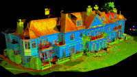 Cadmap utilise Leica Cyclone software to register, edit and refine raw point cloud data. We remove unwanted elements such as trees and generate building sections across full structures. Following registration, data is transferred into Leica Cloudworx for AutoCAD 2016, where the drawing process commences. Final outputs can be rendered using Revit and 3DS Max.