Business Details
50+ Years
experience
Professional Land & Building Surveyors in Ipswich
EDI Surveys has been delivering precision surveying services across the UK since 1973. Our reputation is built on decades of technical expertise, cutting-edge technology, and unwavering commitment to client satisfaction. We specialise in topographic, building, and utility surveys, supported by advanced tools from industry leaders like Leica and DJI. Our team of certified professionals holds CSCS cards and undergoes rigorous annual training in safety and technical competencies. As ISO 9001/14001 and SSIP-accredited specialists, we combine environmental responsibility with exacting standards. With a client base spanning national agencies to local developers, we provide tailored solutions for infrastructure, construction, and heritage projects.Our Ipswich headquarters ensures strategic accessibility to London and the Midlands while maintaining a nationwide service footprint. We prioritise transparent communication, data-driven decision-making, and long-term client partnerships founded on trust. From coastal erosion monitoring to 3D laser scanning of historic structures, our work empowers informed project outcomes. As a family of surveying professionals with cumulative centuries of experience, we remain dedicated to advancing the science of measurement while upholding traditional values of precision and integrity.
Services
Topographic Surveys
Measured Building Surveys
Underground Utility Surveys
3D Laser Scanning
Drone Surveys
CCTV Drainage Surveys
Coastal Surveys
Volume Surveys
Boundary Surveys
Movement Monitoring
Details
- Year established: 1973
Highlights and features
- 50+ years of surveying expertise since 1973
- ISO 9001/14001 quality and environmental certifications
- Latest surveying technology from Leica and DJI
- Fully trained team with CSCS and DBS certifications
- Comprehensive nationwide service coverage
Associations and certifications
- ISO 9001
- ISO 14001
- SSIP
Services
Topographic Surveys
Our topographic surveys capture precise elevation and feature data for sites ranging from small gardens to major infrastructure projects. Using GPS and total stations, we produce detailed plans showing natural and man-made features. This data supports planning applications, construction projects, and environmental assessments across the UK.
3D Laser Scanning
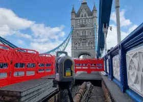
We employ eye-safe laser technology to create detailed point cloud models of buildings and structures. This non-invasive method captures millions of data points for accurate 3D representations. Ideal for heritage buildings and complex engineering projects, our scanning services support renovation, documentation, and structural analysis with millimetre precision.
Underground Utility Surveys
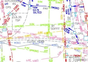
Using electromagnetic location and ground-penetrating radar, we map underground utilities to PAS128 standards. Our surveys identify water, gas, electricity, and telecom services to prevent damage during excavation. This critical data supports safe site development and infrastructure planning across diverse project types.
Measured Building Surveys
We produce accurate floor plans, elevations, and sections for residential, commercial, and historic properties. Utilising laser scanners and total stations, our surveys document existing conditions for renovation, valuation, or planning purposes. Detailed CAD drawings ensure precise spatial understanding for architects and developers.
Drone Surveys
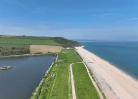
Our UAV surveys capture high-resolution aerial data for inaccessible or large-scale sites. Fixed-wing and multi-rotor drones collect photogrammetric data for topographic mapping, stockpile volume calculations, and site monitoring. This efficient method reduces survey time while maintaining survey-grade accuracy for construction and environmental projects.
People
Richard Allen
Managing Director
With over 30 years in surveying, Richard oversees business operations and strategic direction. He graduated from Newcastle University with a BSc in Surveying Science and brings extensive technical and managerial expertise to EDI Surveys.
Luke Warvill
Director
Luke manages technical operations and business development. He joined EDI in 1999 and has driven technological advancements while building strong industry relationships through his commercial and surveying expertise.
Tina Connor
Director
Tina leads project management and quality assurance systems. With surveying experience since 1994, she specialises in topographic and coastal surveys while developing strategic business initiatives.
Adam Rose
Survey Manager
Adam oversees coastal survey operations and equipment maintenance. Starting his career at EDI in 1994, he has developed extensive field experience managing complex survey projects across diverse environments.
Tony Andrews
Survey Manager
Tony specialises in laser scanning and Revit modelling. With a BSc in Surveying and Mapping Sciences, he brings technical expertise to measured building surveys and point cloud data processing.
Questions
What surveying services do you offer?
We provide topographic, building, utility, 3D laser scanning, drone, and coastal surveys. Our services cover land development, infrastructure projects, and heritage conservation across the UK.
How long have you been in business?
EDI Surveys has delivered professional surveying services since 1973, with our team collectively holding centuries of combined industry experience.
What technology do you use?
We utilise Leica and Trimble total stations, DJI drones, 3D laser scanners, and ground-penetrating radar. Our equipment meets ISO-certified standards for precision and reliability.
Are you accredited?
Yes, we hold UKAS ISO 9001 (quality) and ISO 14001 (environmental) accreditations, along with SSIP health and safety certification.
Do you work nationwide?
Based in Ipswich, we serve clients throughout the UK, from London and the Midlands to remote coastal locations in Cornwall and Scotland.