Business Details
28 Years
experience
Professional Surveying Services Chesterfield
Established in 1998, Peak Surveying Services has built a reputation for delivering precise and reliable surveying solutions across the UK. Our team utilises cutting-edge Leica equipment and advanced drone technology to provide tailored services for clients in construction, architecture, mining, and land development sectors. With a commitment to exceeding industry standards, we offer nationwide coverage from our base in the Peak District, ensuring high-quality topographic surveys, volumetric calculations, and 3D modelling. Our Civil Aviation Authority licensing and Avetta accreditation demonstrate our adherence to safety and compliance protocols.Over 25 years, we've maintained a client-centric approach, treating every project - whether large-scale quarry surveys or architectural groundwork - with equal dedication. Our investment in continuous technological innovation, including orthomosaic generation and visual impact assessment software, ensures we remain at the forefront of surveying excellence while maintaining competitive pricing and timely delivery.
Services
Topographic Surveys
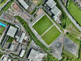
Drone Aerial Photography
3D Modelling
Volumetric Calculations
Visual Impact Assessments
Setting Out Services
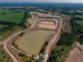
Quarry Surveys
Orthomosaic Generation
Geological Cross-Sections
Digital Mapping
Details
- Year established: 1998
Highlights and features
- 25+ years' experience in land surveying and drone operations
- Utilise state-of-the-art Leica survey equipment and drone technology
- Tailored solutions for construction, mining, and architectural sectors
- Nationwide service with local knowledge of Peak District
- CAA-licensed drone operators with public liability insurance
Associations and certifications
- Civil Aviation Authority
- Avetta
- Drone Pilot Academy
- Safety Pass Alliance
What people say
Consistently accurate
Reliable service
Competitive pricing
Timely delivery
Professional approach
Services
Topographic Surveys
Our topographic surveys provide detailed terrain analysis using state-of-the-art Leica equipment. This service creates accurate elevation models and feature mapping for construction planning and land development. Clients benefit from precise data that supports informed decision-making for projects ranging from housing developments to industrial sites.
Drone Aerial Photography
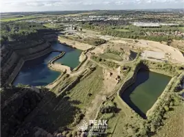
CAA-licensed drone operations capture high-resolution aerial imagery and 4K video for site documentation. Our orthomosaic generation creates georeferenced maps by stitching hundreds of overlapping images. This service provides unique perspectives for project monitoring, marketing materials, and planning applications with rapid turnaround times.
3D Modelling
We create detailed 3D models for visual impact assessments and development planning. Using survey data and geospatial software, this service enables virtual walkthroughs and zone of visual impact analysis. Clients gain valuable insights into potential development impacts during the planning stage, supporting effective mitigation strategies.
Volumetric Calculations
Specialist volumetric calculations provide precise material measurements for quarrying and construction projects. Our services include stockpile analysis and excavation volume assessments using reflectorless laser scanning. Clients receive accurate data for inventory management, project costing, and operational planning across multiple industries.
Setting Out Services
We provide precise setting out for building foundations and infrastructure projects using digital surveying techniques. This service ensures accurate implementation of architectural plans on-site, reducing errors and rework. Clients benefit from efficient project execution with guaranteed dimensional accuracy for all construction phases.
Questions
What surveying services do you offer?
We provide topographic surveys, 3D modelling, volumetric calculations, setting out services, and drone aerial photography for construction, mining, and architectural sectors.
Are you licensed for drone operations?
Yes, we hold CAA Operational Authorisation (OA) PAndEUAS2728 with DPA-C qualified pilots and £1m public liability insurance for aerial work.
How quickly can you complete a survey?
Most surveys are completed within 1-3 working days depending on site size and complexity, with urgent requests accommodated where possible.
Do you operate nationwide?
Yes, while based in Chesterfield, we provide surveying services across the UK with particular expertise in Peak District and surrounding regions.
What industries do you work with?
We serve construction companies, architects, mining operations, landfill operators, civil engineers, and land developers with tailored surveying solutions.
How do you ensure survey accuracy?
We use state-of-the-art Leica equipment, conduct comprehensive site risk assessments, and follow strict quality control procedures for all survey deliverables.